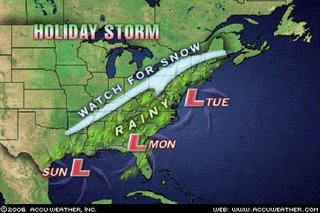
Here is the latest on the Monday Night/Tuesday storm potential.
As of now, it appears the low will track up from the Gulf States, into eastern Pennsylvania and then into Southern New England. With the storm center so close, it will be harder to change the rain over to snow and our snow totals will be lower as a result. It is still early, so make sure to check back for further updates. Here are the complete details:
Monday evening: Rain arrives and increases in intensity and coverage
Overnight: Rain mixes with snow over higher elevations and gradually changes over to all snow in the early morning hours Tuesday.
Tuesday morning: Snow and wind.
Tuesday afternoon: Scattered snow squalls as lake effect kicks in
Total snow accumulaitons: 3-5"
Check back for another update later tonight! Have a safe and merry Christmas!
The Groton Weather Blog is just another dimension of the Groton Weather experience. I use the blog for longer range forecasts, updates and more in depth information on major events, as well as educational purposes. Please leave comments any time you wish; I am hoping this becomes more interactive! And be sure to check out the homepage at www.grotonweather.com!
Sunday, December 24, 2006
Wednesday, December 20, 2006
White Christmas
Well....it looks like we may miss out on a white Christmas this year. Now the day after Christmas...that could be a different story (see below). As you are well aware, we have no snow. There will only be one more storm system to move through before Monday, and it looks as if it will be too warm for anything but rain (although there are some concerns about freezing rain to start Friday night....). There may be a tad of lake effect Sunday, but I doubt it will be anything more than what we got Tuesday (a few flurries).
Now for Tuesday. If you have travel plans Tuesday, you will want to keep a close eye on this. (Feel free to email me requesting updates. See "services and contacts" link on the homepage.) A storm system will move up the east coast and has the potential to develop into a classic nor' easter. While there is not enough cold air for the cities to get anything but rain, as of now it looks like enough might penetrate to make this a snow event for us. Of course, this is still way too early to be sure about anything. The cold air might not make it in. Or the storm may head further east and totally miss us. A lot of times with these types of storms, it is hard to tell exactly what they will do until they have already done it! So CHECK BACK! I will be updating!
Now for Tuesday. If you have travel plans Tuesday, you will want to keep a close eye on this. (Feel free to email me requesting updates. See
 "services and contacts" link on the homepage.) A storm system will move up the east coast and has the potential to develop into a classic nor' easter. While there is not enough cold air for the cities to get anything but rain, as of now it looks like enough might penetrate to make this a snow event for us. Of course, this is still way too early to be sure about anything. The cold air might not make it in. Or the storm may head further east and totally miss us. A lot of times with these types of storms, it is hard to tell exactly what they will do until they have already done it! So CHECK BACK! I will be updating!
Subscribe to:
Comments (Atom)