Wednesday, November 29, 2006

Wild Weather

A major storm system is causing some real crazy weather. Parts of Oklahoma, Arkansas, and Missouri are currently under both Winter Storm Warnings AND a Tornado Watch. Around noon today, it was in the low 70's in Muskogee, Oklahoma. 140 Miles to the west in Oklahoma City, it was in the low 40's. This kind of crazy weather is headed our way for Friday.

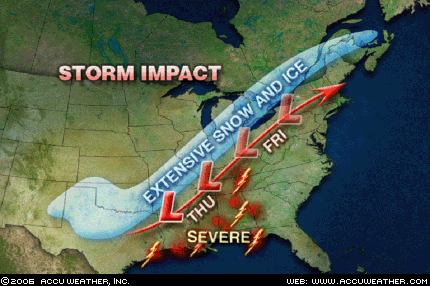
As of right now, it appears that the low pressure area will either stay to our west or move right over us. Either way, this does not look to be a major snow event for us. Places like Chicago, into Michigan and Ontario could get pounded though. Because the low will stay to our west, we will be in the warm sector. As illustrated in the Oklahoma example, this is quite a drastic difference. While we won't be in the 70's, we could come close on Thursday. Friday will stay in the 50's, but that will be enough to get some thunderstorms going. Because this is such a powerful storm system, high winds in the storms are likely. We have already been placed in the "slight" category for severe storms Friday by the Storm Prediction Center.

There is still a good deal of uncertainty with this storm, so make sure to check for updates both here on this blog, and on the homepage at www.grotonweather.com

Friday, November 24, 2006

Enjoy the warmth

We are currently in the middle of a very nice stretch of weather. The temperatures have been just average (which equates to a tad chilly for most), but that is starting to change. The next few days will see upper 50's, with 60 possible. The one cool day looks to be Tuesday. But let me forewarn you: do not get too used to the warmth.

A massive dome of arctic air (to the tune of -50F in the Yukon) has been building over Alaska and Canada. A storm system just starting to come into the Northwest will open the floodgate for this cold air. This storm system will not get to us until next weekend, but it does appear it will get very cold over much of the nation. And, of course, any time it turns cold, the Lake Effect will get going.


An interesting note about the timing of this arctic air. I have been keeping statistics for late November/Early December since 2003. All 3 of the previous years have seen a very cold and snowy first week of December. It looks like this year will make it 4.

Thursday, November 16, 2006

Severe Weather & Downed Website

what a crazy day, huh? Around noon today, a line of very strong thunderstorms formed in Central Pennsylvania and raced our way. These storms left a path of destruction as they blasted through Central New York. Here are just a few of the more impressive reports:

  • A roof was blown off a building in Van Etten
  • A tree was uprooted on Elm Street here in Groton (winds estimated at 55-65 mph)
  • A 74 mph wind gust was recorded atop the Carrier Dome in Syracuse....that is hurricane force!
  • Flash flooding, especially in the Binghamton area where it is still raining heavily and over 200 people hav had to be rescued (as of 11 PM) and a Mudslide has closed part of Interstate 88
  • Two unconfirmed tornadoes in Marietta and Chitnago
More on the damage in the coming days.

Speaking of the coming days, my website will be down Friday afternoon through Sunday.

Wednesday, November 01, 2006

First Accumulating Snow expected tonight!

This morning when I updated my website, none of the sources I use to create my forecasts said anything about snow, hence my forecast for partly cloudy skies. Apparently things have changed. It now looks like a storm system moving into the northeast will reach into our area, bringing a mixed bag of precipitation. It should start as rain before mixing with and changing to all snow. Accumulations will be light, but they should be there. Expect no more than an inch overnight, but seeing white may be a bit of a shock after yesterday's high of 67!

I am hoping to get the newsletter done very shortly. In fact, I will stop messing around with my blog and get working on that!