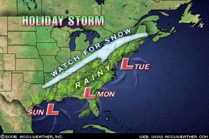
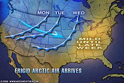
Here is the latest on the Monday Night/Tuesday storm potential.
As of now, it appears the low will track up from the Gulf States, into eastern Pennsylvania and then into Southern New England. With the storm center so close, it will be harder to change the rain over to snow and our snow totals will be lower as a result. It is still early, so make sure to check back for further updates. Here are the complete details:
Monday evening: Rain arrives and increases in intensity and coverage
Overnight: Rain mixes with snow over higher elevations and gradually changes over to all snow in the early morning hours Tuesday.
Tuesday morning: Snow and wind.
Tuesday afternoon: Scattered snow squalls as lake effect kicks in
Total snow accumulaitons: 3-5"
Check back for another update later tonight! Have a safe and merry Christmas!
Sunday, December 24, 2006
Wednesday, December 20, 2006
White Christmas
Well....it looks like we may miss out on a white Christmas this year. Now the day after Christmas...that could be a different story (see below). As you are well aware, we have no snow. There will only be one more storm system to move through before Monday, and it looks as if it will be too warm for anything but rain (although there are some concerns about freezing rain to start Friday night....). There may be a tad of lake effect Sunday, but I doubt it will be anything more than what we got Tuesday (a few flurries).
Now for Tuesday. If you have travel plans Tuesday, you will want to keep a close eye on this. (Feel free to email me requesting updates. See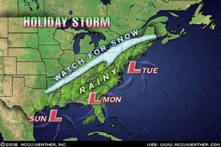 "services and contacts" link on the homepage.) A storm system will move up the east coast and has the potential to develop into a classic nor' easter. While there is not enough cold air for the cities to get anything but rain, as of now it looks like enough might penetrate to make this a snow event for us. Of course, this is still way too early to be sure about anything. The cold air might not make it in. Or the storm may head further east and totally miss us. A lot of times with these types of storms, it is hard to tell exactly what they will do until they have already done it! So CHECK BACK! I will be updating!
Now for Tuesday. If you have travel plans Tuesday, you will want to keep a close eye on this. (Feel free to email me requesting updates. See
 "services and contacts" link on the homepage.) A storm system will move up the east coast and has the potential to develop into a classic nor' easter. While there is not enough cold air for the cities to get anything but rain, as of now it looks like enough might penetrate to make this a snow event for us. Of course, this is still way too early to be sure about anything. The cold air might not make it in. Or the storm may head further east and totally miss us. A lot of times with these types of storms, it is hard to tell exactly what they will do until they have already done it! So CHECK BACK! I will be updating!
Wednesday, November 29, 2006
Wild Weather
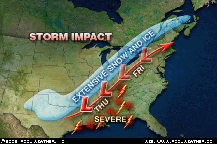
A major storm system is causing some real crazy weather. Parts of Oklahoma, Arkansas, and Missouri are currently under both Winter Storm Warnings AND a Tornado Watch. Around noon today, it was in the low 70's in Muskogee, Oklahoma. 140 Miles to the west in Oklahoma City, it was in the low 40's. This kind of crazy weather is headed our way for Friday.
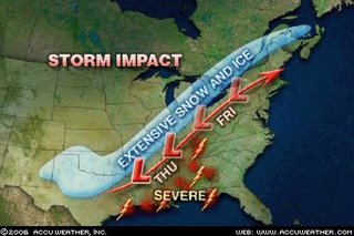 As of right now, it appears that the low pressure area will either stay to our west or move right over us. Either way, this does not look to be a major snow event for us. Places like Chicago, into Michigan and Ontario could get pounded though. Because the low will stay to our west, we will be in the warm sector. As illustrated in the Oklahoma example, this is quite a drastic difference. While we won't be in the 70's, we could come close on Thursday. Friday will stay in the 50's, but that will be enough to get some thunderstorms going. Because this is such a powerful storm system, high winds in the storms are likely. We have already been placed in the "slight" category for severe storms Friday by the Storm Prediction Center.
There is still a good deal of uncertainty with this storm, so make sure to check for updates both here on this blog, and on the homepage at www.grotonweather.com
Friday, November 24, 2006
Enjoy the warmth
We are currently in the middle of a very nice stretch of weather. The temperatures have been just average (which equates to a tad chilly for most), but that is starting to change. The next few days will see upper 50's, with 60 possible. The one cool day looks to be Tuesday. But let me forewarn you: do not get too used to the warmth.
 A massive dome of arctic air (to the tune of -50F in the Yukon) has been building over Alaska and Canada. A storm system just starting to come into the Northwest will open the floodgate for this cold air. This storm system will not get to us until next weekend, but it does appear it will get very cold over much of the nation. And, of course, any time it turns cold, the Lake Effect will get going.
An interesting note about the timing of this arctic air. I have been keeping statistics for late November/Early December since 2003. All 3 of the previous years have seen a very cold and snowy first week of December. It looks like this year will make it 4.
Thursday, November 16, 2006
Severe Weather & Downed Website
what a crazy day, huh? Around noon today, a line of very strong thunderstorms formed in Central Pennsylvania and raced our way. These storms left a path of destruction as they blasted through Central New York. Here are just a few of the more impressive reports:
Speaking of the coming days, my website will be down Friday afternoon through Sunday.
- A roof was blown off a building in Van Etten
- A tree was uprooted on Elm Street here in Groton (winds estimated at 55-65 mph)
- A 74 mph wind gust was recorded atop the Carrier Dome in Syracuse....that is hurricane force!
- Flash flooding, especially in the Binghamton area where it is still raining heavily and over 200 people hav had to be rescued (as of 11 PM) and a Mudslide has closed part of Interstate 88
- Two unconfirmed tornadoes in Marietta and Chitnago


Speaking of the coming days, my website will be down Friday afternoon through Sunday.
Wednesday, November 01, 2006
First Accumulating Snow expected tonight!
This morning when I updated my website, none of the sources I use to create my forecasts said anything about snow, hence my forecast for partly cloudy skies. Apparently things have changed. It now looks like a storm system moving into the northeast will reach into our area, bringing a mixed bag of precipitation. It should start as rain before mixing with and changing to all snow. Accumulations will be light, but they should be there. Expect no more than an inch overnight, but seeing white may be a bit of a shock after yesterday's high of 67!
I am hoping to get the newsletter done very shortly. In fact, I will stop messing around with my blog and get working on that!
I am hoping to get the newsletter done very shortly. In fact, I will stop messing around with my blog and get working on that!
Saturday, October 28, 2006
New Quiz!
I have created a new quiz for my website! It can be found on the "Quiz Page," which is linked to on my homepage. This quiz is on Winter Preparedness and winter safety. I tired not to make it as hard as the last one. I even put the web address of the PDF file I got all the information from. I made this quiz now because the National Weather Service has declared next week (October 29-November 5) "Winter Preparedness Week." Happy quizzing! Let me know how you do!
Friday, October 27, 2006
Hold onto your hats!
A major storm system is heading our way and should make this weekend fun...If you like "yucky" weather like me that is! The rain should start later tonight and fall through most of Saturday. As the low pressure really gets wound up and moves up the coast of New England Saturday afternoon, the winds will start to scream. At this time, a high wind watch is in effect for most areas east of Michigan, including us. Winds could gust up to 60 mph at times, so if you still have lawn furniture out, securing it or anything else that could blow around would be a good idea. The rain will be falling hard and we should get 1-2", maybe more. Rain amounts on the higher end of the spectrum could cause some minor flooding. However, more importantly, the rain will loosen the soil around the trees and cause some to fall.
Last night, I got caught up in all my weather stats and records. I had really fallen behind, but everything is up to date. I haven't put any of it back on the website yet...I am going to look into an easier way of doing it. You will notice I do now have monthly and yearly rain totals up in the almanac section. The quiz I was talking about last post, as well as the October/November Newsletter I am hoping to get done this weekend! Have a good weekend and don't get blown away!
Last night, I got caught up in all my weather stats and records. I had really fallen behind, but everything is up to date. I haven't put any of it back on the website yet...I am going to look into an easier way of doing it. You will notice I do now have monthly and yearly rain totals up in the almanac section. The quiz I was talking about last post, as well as the October/November Newsletter I am hoping to get done this weekend! Have a good weekend and don't get blown away!
Thursday, October 19, 2006
Who loves rainy nights?
If you love rainy nights, you are in for a treat tonight. There is a very large area of rain heading our way out of the Ohio Valley, not to mention the rain we have already gotten, which totals 0.51" so far. By tomorrow morning, rain totals could be in the 1-2.5" range, but flooding isn't expected. The rain will move out tomorrow afternoon and leave just showers, both rain and snow, around for Friday night.
Today while visiting the National Weather Service in Binghamton's homepage for.....say the 7th time (no exaggeration)...I noticed that October 29-November 4 is "Winter Preparedness Week." This means the NWS (National Weather Service) will do a bunch of things to inform the public of ways to stay safe this winter. I have decided to make my next quiz on material I find from the NWS's 34 page PDF File. (Don't worry, it is 34 pages of big pictures and few words...) I hope to get that quiz done by the 29th, but that depends on the homework load next week!
One other note, I will be out of town this weekend, so I am not sure when and if I will be updating my webpage. I probably will give an update Saturday morning, but I do not know about Sunday morning.
Wednesday, October 18, 2006
First Post!
Welcome to the Grotonweather blog! I thought this might be a good thing to have. I can write things about my webpage, www.grotonweather.com, or my monthly newsletter, or just the weather in general. This way you will be informed of any changes I make or new features to check out!
Some of you may have noticed I have not yet put out an October issue to my newsletter. Be patient...it will come eventually. School, work and college applications have kept me very busy, and in the free time I have had, I reformatted my webpage and started playing around with the blog idea! I have decided I am going to combine October and November's newsletter since October is already half over. This double issue will most likely cover lake effect snow and October snowstorms, specifically the Buffalo snowstorm last week and last October's Southern Tier storm that didn't give us more than a dusting.
For my website, I am currently working on a second quiz for my quiz page. I will try not to make it as hard as the last one, but so far, it looks kinda hard. They are more learning tools than testing what you know anyways, so don't feel bad if you do really really bad. If you haven't yet, please take a second to sign my guestbook. The link to it is right above the daily forecasts and to the right of the date and time I last updated the daily forecasts. The link is an image that looks like this:

Spread the word about my webpage! The more people that know, the better!
Some of you may have noticed I have not yet put out an October issue to my newsletter. Be patient...it will come eventually. School, work and college applications have kept me very busy, and in the free time I have had, I reformatted my webpage and started playing around with the blog idea! I have decided I am going to combine October and November's newsletter since October is already half over. This double issue will most likely cover lake effect snow and October snowstorms, specifically the Buffalo snowstorm last week and last October's Southern Tier storm that didn't give us more than a dusting.
For my website, I am currently working on a second quiz for my quiz page. I will try not to make it as hard as the last one, but so far, it looks kinda hard. They are more learning tools than testing what you know anyways, so don't feel bad if you do really really bad. If you haven't yet, please take a second to sign my guestbook. The link to it is right above the daily forecasts and to the right of the date and time I last updated the daily forecasts. The link is an image that looks like this:
Spread the word about my webpage! The more people that know, the better!
Subscribe to:
Posts (Atom)