Yes, winter is here at last! After a week of cold and light snow, more can be expected next week. We will be on the eastern edge of a major arctic blast that will move into the middle of the country. While at this time it doesn't appear there will be any major storms, with so much cold air in place and being on the edge of the cold dome, there is always potential. If something does develope, it would probably be later in the week.
In webpage news, if you have not yet done so, please take a moment and fill out my survey. Links to the survey can be found in a pop-up window on hte homepage and in the forecast discussion section. Email me if you need help finding it. The Winter Weather Page has been fixed and updated, so 1 out of 3 of last post's projects are complete. Stay warm!
Friday, January 26, 2007
Wednesday, January 17, 2007
Web Page News
Here is a quick update on what I am doing with the web page.
Ask Drew: Another page I am remaking in HTML....I have gotten a couple questions, so be patient and I will get them up ASAP! Sorry for the delay....I haven't forgotten!
Daily Records/Monthly Stats: These pages are currently converted files I have on my computer. When I made this site, I used Yahoo's! Page Builder...which didn't allow me to just upload the files...instead I had to copy and paste that information and type any changes I wanted to make. I am now looking into the possibility of just uploading these files...maybe it will upload the changes I make when I do them on my computer....I'm still exploring...
Winter Weather Homepage: It came to my attention today that I had old snow day forecasts up from last winter on the WW homepage. Sorry for any confusion that caused! Snow day forecasts, along with all winter weather specific forecasts are on the homepage, directly below the forecast discussion. In the meantime, I will hopefully get around to remaking this page in HTML to make it more functional.
While I am working on these sections, I will probably just un-link the links. Like other links that lead to nowhere, I will mark these with an asterisk (*) so you know they are not functional.
In the weather....there could be some hefty lake snows once again Friday night through Sunday. Check out the website for more info starting Thursday morning.
Monday, January 15, 2007
Lake Effect Storm?
While our ice potential this morning didn't live up to its hype, at least here, we are not out of the woods yet. As the storm system responsible for this morning's ice and today's rain moves off to our east, cold, arctic air will spill down from Canada on northwest winds. Now that the ice threat is gone, my sources are finally focusing more on this event. It appears that a lake effect band will set up off the southeast end of Lake Ontario and just north or right over Groton. This lake effect will set up later tonight and last through tomorrow night. By the time it winds down Wednesday morning, there could be significant accumulations. The National Weather Service is saying 5-9" and I tend to agree with them at the time. What does this mean for snow day chances?
Tuesday: Minimal...Only 1 or 2" should fall by tomorrow morning, so I would bet $$ we will have school.
Wednesday: Slight...As of now, it looks like 2-4" will fall during the day tomorrow. That leaves about 3-6" for the overnight. I think most of this will likely fall earlier in the overnight as opposed to closer to daylight. As of now, I am going to say either school as planned or a 1-hour delay. I will update again tomorrow afternoon with a new outlook. Also, check the homepage for updates as well!
Tuesday, January 09, 2007
Where is winter? It's coming...
After a December that saw an average high 11 degrees warmer than December 2005 (44 compared to 33), January has picked up right where December left off. A high of 36 today makes it the first day of the new year we have not gotten above 40. It also marks the first accumulating snow since just after Christmas, and the 2nd since the beginning of December! While it looks like winter out again tonight, by Friday, we will be back into the 40's with rain. That will continue into Sunday. So will it ever stay winter?
The answer is yes. And soon. And in ernest. The rain this weekend will be out ahead of a slow moving, but powerful arctic cold front. Once the front finally moves through, our highs will plummet to new lows for the year. Highs Monday and Tuesday will be in the lower 20's at best.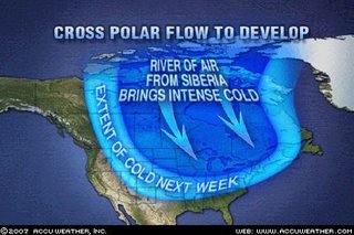 Unlike other cold spells, this one will stick around for a while. In fact, most of the country will see a return to winter as the jet stream heads south, opening the flood gates for cold air to come spilling in. According to accuweather.com, there is even a chance a connection will be made aloft from Siberia, across the North Pole and into Canada and the US. Siberia is colder than Canadian air, so this will only increase the chill. And, of course, lake effect will be an issue since the lakes are way warmer than normal. Hope you didn't sell you snow shovels!
The answer is yes. And soon. And in ernest. The rain this weekend will be out ahead of a slow moving, but powerful arctic cold front. Once the front finally moves through, our highs will plummet to new lows for the year. Highs Monday and Tuesday will be in the lower 20's at best.
 Unlike other cold spells, this one will stick around for a while. In fact, most of the country will see a return to winter as the jet stream heads south, opening the flood gates for cold air to come spilling in. According to accuweather.com, there is even a chance a connection will be made aloft from Siberia, across the North Pole and into Canada and the US. Siberia is colder than Canadian air, so this will only increase the chill. And, of course, lake effect will be an issue since the lakes are way warmer than normal. Hope you didn't sell you snow shovels!
Subscribe to:
Posts (Atom)