The answer is yes. And soon. And in ernest. The rain this weekend will be out ahead of a slow moving, but powerful arctic cold front. Once the front finally moves through, our highs will plummet to new lows for the year. Highs Monday and Tuesday will be in the lower 20's at best.
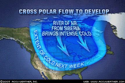 Unlike other cold spells, this one will stick around for a while. In fact, most of the country will see a return to winter as the jet stream heads south, opening the flood gates for cold air to come spilling in. According to accuweather.com, there is even a chance a connection will be made aloft from Siberia, across the North Pole and into Canada and the US. Siberia is colder than Canadian air, so this will only increase the chill. And, of course, lake effect will be an issue since the lakes are way warmer than normal. Hope you didn't sell you snow shovels!
No comments:
Post a Comment